
Highways England’s ‘Options Identification’ period for the Arundel Bypass has come to an end. They will now prepare their selected ‘Options’ for a ‘public consultation’ next summer, like the one about the Chichester bypass this summer.
Will Highways England tell the public what ‘Options’ they have selected to investigate in more detail?
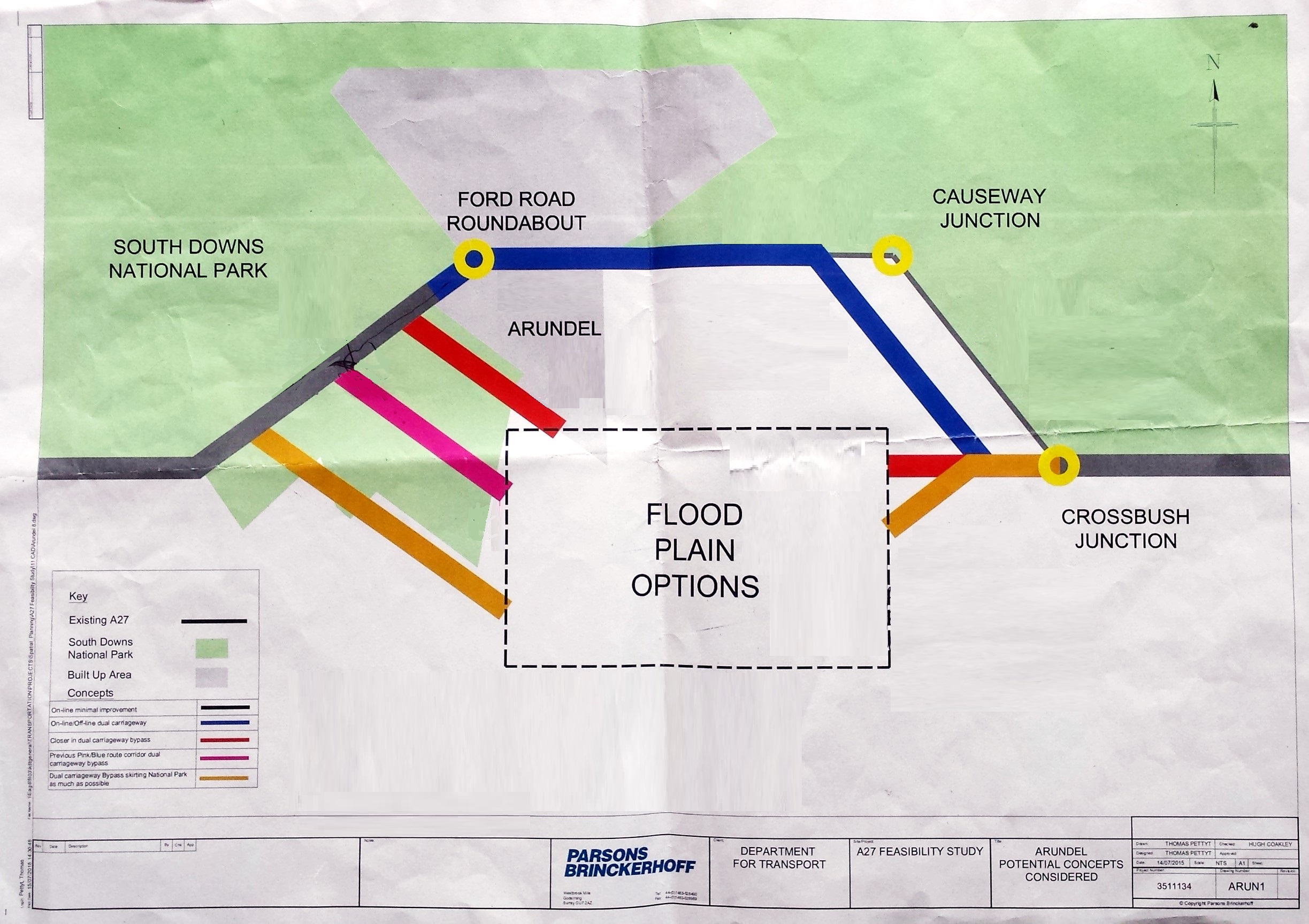
We hope they will tell us, but we won’t be holding our breath. Meanwhile we do know from their 2014 announcement that the Pink-Blue route from 1993, with the western end crossing Tortington Common, ‘Option A’ in their 2015 ‘Feasibility Study’ reports, is the ‘starting point’ for the exercise, so is likely to be included.
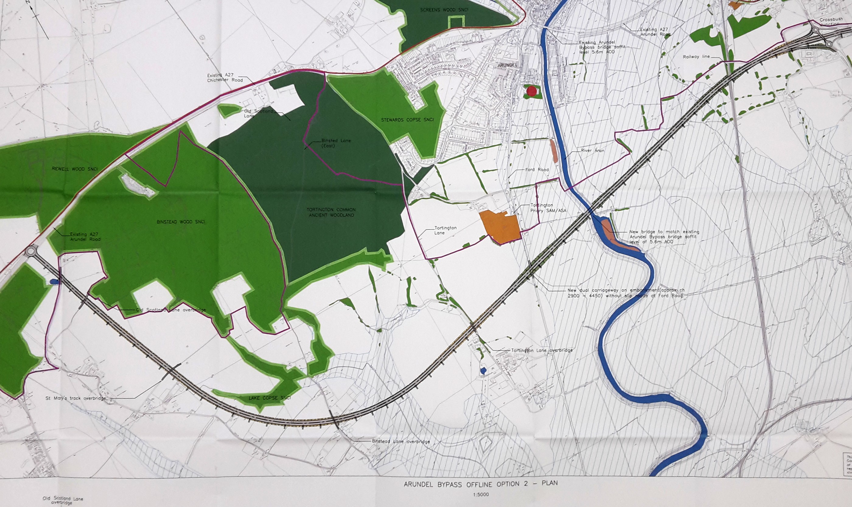
What else do we know? ABNC’s Freedom of Information request in March this year showed that a map of a route even further south, through Tortington and Binsted, appeared in unpublished reports of 2004 and 2006. HE’s Option B, ‘longer to avoid the National Park’, from its 2015 reports, appears to be the same route. This route, or something very close to it, is what they wanted to include among their Consultation ‘options’, for comparison with the Pink-Blue route.
But have they included it in the ‘Identification’ shortlist, or have they already dropped it based on early compelling evidence that this most expensive of the Options is also too damaging to be viable in planning terms? ABNC has made a strong case against it. We prepared and sent off in late September an ‘Evidence Report’, a binder weighing 2.6 kilos, demonstrating that the Binsted option should not be among the consultation’s ‘Options’. See www.arundelbypass.co.uk/evidence-report.
Chapter 1 of our Evidence Report shows the route is not viable because it contravenes important planning policies both at Binsted and at Tortington. This is supported by chapters on Binsted’s history, Arts Festival and community events, a professional Environmental Impact Assessment about the effect on wildlife, and printouts from the ABNC, MAVES and Binsted websites including a petition of over 1400 signatures against the route.
Will Highways England listen to the evidence that has been presented?
We hope so, but Highways England does not, so far, have a good track record, in this exercise, of listening to local knowledge. There was supposed to be ‘engagement’ with local groups and Councils – including Parish Councils – in the ‘Options identification’ period. HE failed to answer a letter objecting to this route from Walberton Parish Council, failed to invite them to a stakeholder meeting, and refused to meet with ABNC.
Be prepared for some intensive campaigning next year if Highways England ignores the Report and persists with this route.
How do we know about where the Binsted Option route would go, if Highways England have kept it as one of their Options to work up for the public consultation?
No maps were issued in the 2015 reports, but the route matches the outermost one shown on HE’s ‘schematic’ map of 2015. An ‘alternative alignment’ for the north end was described in the 2015 reports with a flyover junction at Avisford. Both versions of Option B are obviously catastrophic for Binsted village and also for Tortington village. Both still do damage the National Park, by destroying some of it, severing parts of it and affecting its setting and connections to the countryside. Both severely affect the Arundel watermeadows. This schematic map of 2015 appears to show something very similar to the more detailed map above, which comes from Highways England’s 2004 report by Bullen Consultants.
Emma Tristram (Secretary, Arundel Bypass Neighbourhood Committee)