
Arundel bypass: A27 Study fails to fix a route for Option B – perhaps deliberately?
It seems extraordinary that although the ‘A27 Feasibility Study’ was published in March, the route of Option B for the Arundel bypass is still not known for certain. No map is given, and the description (at Report 3, paras 5.2.4. to 5.3.2) is contradictory for most of the route. The ‘old Option B’, through south Binsted and partially through Walberton (based on a map copied at the Study’s stakeholder meeting last August) has disappeared, perhaps as a result of the concern it caused. (See https://www.gov.uk/government/publications/a27-corridor-feasibility-study-technical-reports.)
The north end of the new Option B (i.e. the junction with the A27) is clearly described. Its proposed junction is now either a T junction roundabout ‘0.8 km east of the Yapton Lane/A27 junction’ (known as Avisford), or, in the ‘second alignment’ they mention, a flyover actually at Avisford. Both junctions would be within the National Park, as would the section of the new Option B leading to the junction from Scotland Lane.
For the rest of the new Option B, it seems Parsons Brinckerhoff cannot decide between a new Option B similar to old ‘Green route 1’, passing through the National Park – which would be humiliating for them, after all their headings and tables call Option B ‘longer to avoid the National Park’ – or a new route hugging the border of the Park, dividing Binsted in two from south to north, passing very close to houses (several listed) and the 12th-century church, and destroying Binsted Nursery and the field where the Strawberry Fair happens every year.
The Study gives clues to both these routes. One paragraph mentions four overbridges, over Binsted Lane (East), ‘Spinningwheel’, Scotland Lane, and Binsted Lane (West). If they mean Spinningwheel Copse, a wood within Binsted Woods and the National Park (and incidentally a marvellous site for bluebells), they mean a new Option B similar to old ‘Green route 1’ – now within the National Park. This is shown in red on my conjectural Fig 1 below. Other pointers, such as most of the lengths in km. and directions given, and mention of Meadow Lodge being impacted, suggest a route mostly outside the National Park, i.e. the route shown in orange on Fig. 1. One crucial direction, ‘before turning slightly to the east’ (paragraph 5.2.12), is obviously a mistake (or a deliberate confusion). ‘North’ or ‘south’ must be meant, suggesting either one or the other of these routes.
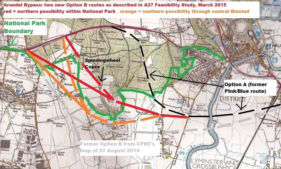
Both these ‘new Option Bs’ would have an ‘alternative alignment’ to a flyover junction at Avisford. Green 1 was rejected (in 1993 after comparison with Pink/Blue, now Option A) partly because its T junction with the A27 would, it was recognized, soon be replaced by a smoother curve and a flyover at Avisford, which would destroy Hundred House Copse. This suggests that both these ‘new Options Bs’ are worse than Option A.
The ambiguity described above, and lack of a map, are very hard on those whose houses are on or near Option B. It also means there can be no meaningful discussion of routes in advance of a public consultation – which is perhaps just the situation the garbled description in the Study was meant to provoke. Or is it just plain incompetence?
Emma Tristram [Letter to West Sussex Gazette 2 April 2015]