
Highways England carries on with its usual shower of inaccurate statements and euphemisms about their A27 Arundel Bypass Grey route in its latest document. This ‘Scoping Report’, on the Planning Inspectorate website, outlines the scope of the coming Environmental Impact Assessment. All their 'fake news' contributes to hiding or downplaying the damage the Grey route would do. See https://infrastructure.planninginspectorate.gov.uk/projects/south-east/a27-arundel-bypass/?ipcsection=docs.
Here are some highlights (or rather, lowlights):
13.4.10. ‘No community facilities are located directly alongside the new route.’
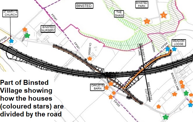
St Mary’s church, Binsted, listed Grade II, 12th century, is 30m away and its churchyard wall is 10m away. Grey is on a viaduct at this point and traffic would be on a level with the top of the churchyard wall.
 13.4.4. ‘The proposed scheme runs south of the village of Binsted.’ The phrase is used many times.
Grey cuts Binsted village in half, crossing its only access road twice. Highways England must know this, as they have designed in two 7m high overbridges to give access to houses on both sides of the Grey route.
13.4.5. ‘The residential roads of Copse Lane, Tye Lane, Yapton Lane, Binsted Road and Tye Lane are all passed by the proposed scheme.’
They are crossed by it.
13.4.12. The Grey route is described as ‘crossing the boundary’ of the Golf Course.
The Grey route crosses four boundaries of the Golf Course and the Course itself.
13.5.7. HE recognise the damaging effect the ‘construction phase’ will have on ‘severance of communities’ but do not mention the ‘operational phase’ (when the road is actually used). As the Parish Council puts it, ‘A quiet peaceful countryside area that includes historic villages and tight-knit communities will become severed by the presence of the A27 bypass and associated viaducts, and will become dominated by the presence of these urbanising features and the lack of quiet and peace that once existed.’
8.4.10. ‘The settlements of Crossbush, Tortington, Binsted, Walberton and Fontwell…approximately follow the route of the proposed scheme.’
Euphemistic. The scheme would have a damaging impact on all these communities.
7.4.2. ‘Listed buildings…within settlements include 20 within Walberton and six within Slindon.’
There are 62 listed buildings in Slindon and 39 in Walberton Parish.
Habitat maps 1 and 5 in Fig. 3 show ‘West of Yapton Lane’ as ‘Cultivated Disturbed Land (Amenity and Arable Grassland)’. This area is now a part-built housing development, with 40 houses mothballed and unsellable because of the Grey route.
Walberton Parish Council, an official consultee on the document, has submitted a good critique of this 'Scoping Report'. It is on their website under ‘Arundel Bypass’. Other comments (such as those from members of the public) will not, we are told, be taken into account as they are not from official consultees – they will simply be passed to Highways England. Comments by bodies such as WSCC, Historic England and Natural England are in the ‘Scoping Opinion’ on the PINS website.
On this showing, we can expect HE to pursue the same unscrupulous tactics in the Statutory Consultation, scheduled for later this year.
The struggle continues.