
Woodland south of the A27 west of Arundel was included in the National Park because it met the criteria.
Pro-bypass campaigners frequently say that woodland south of the A27, west of Arundel, was wrongly included in the South Downs National Park, since it was not an AONB, and that this was the result of anti-bypass lobbying. A recent example of this is Councillor Paul Dendle’s email to Mike Tristram of 12 January 2015, which states ‘Unfortunately some green campaigners lobbied to have the boundary to be south of the A27 in an attempt to stop the bypass’.
This is mistaken. The woodland south of the A27 was included by the Countryside Agency because it met the criteria – which are natural beauty, and markedly superior recreational experience.
The process of choosing the boundary
The process of looking at what to include can be seen in the Countryside Agency’s paper AP01/04, of 2001, by Marian Spain. All the relevant AONBs were evaluated, as were some areas outside the AONBs that were felt to meet the criteria: ‘some areas merit minor variations (mainly extensions) to the existing AONB boundaries’. This was an important point, later expanded: ‘There were also areas which had not been previously designated as AONBs but which were now considered to meet both criteria for designation as a National Park. It would be important to ensure that the area of search covered these areas.’
The area west of Arundel was discussed in detail under two of the 10 ‘Landscape Character Areas’. LCA2, ‘Central Wooded Chalk Uplands’, contains a careful assessment of ‘west of Arundel south of the A27’. Under ‘Natural Beauty’ the severing effect of the A27 is noted, but ‘the wooded character of this landscape has absorbed much of its visual and noise impact’. Under ‘Opportunities for Open Air Recreation’, rights of way, quiet lanes, interesting and varied woodland, gently undulating topography, and a tranquil environment to walk, ride and cycle are mentioned, as is proximity to Arundel. Under ‘Natural Beauty’ the overall score given of the wooded area is ‘Medium’, under ‘Open Air Recreation’ it is ‘High’. The preamble to the paper stated that areas to be included need not score ‘High’ under both criteria – and many would argue that ‘Medium’ was an underestimate of the beauty of the woods (Binsted Woods and Tortington Common together).
The woods were therefore included on their own merits in spite of not being an AONB.
The area west of Arundel was discussed again under another Landscape Character Area, the ‘Coastal Lowlands’, LCA3. In the whole ‘Coastal Lowlands’ area of the National Park, only two sections met the natural beauty criterion – one was west of Chichester and the other was ‘the area between Walberton and the River Arun’. Criterion 2, ‘superiority of recreational experience’, was ‘dependent on the quality of the environment and is therefore limited to the area west of Chichester and the area between Walberton and the River Arun’.
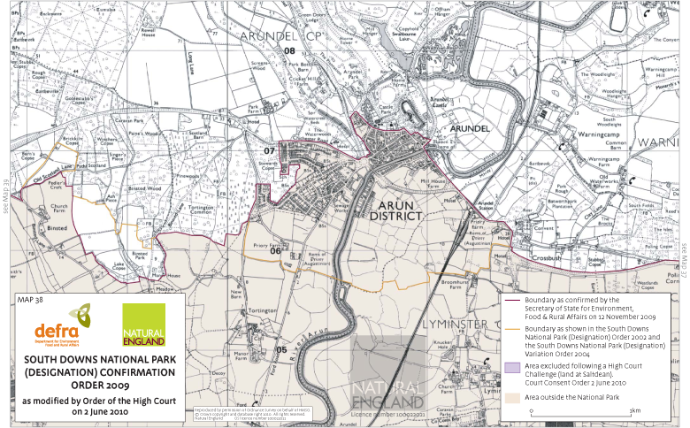
The whole area between Walberton and the River Arun, not just the woodland, was felt by the Countryside Agency to meet the criteria, so the final boundary, which included only the whole of the wooded area and some fields enclosed or nearly enclosed within them, was a tight boundary within a larger area which met the criteria. Many additions within this very good countryside were proposed by objectors such as CPRE during the National Park process, and a small adjustment was made at Binsted – the outlying copses of the main woodland area and a few further fields were added, which had been left out in the draft boundary. Figure 1 shows both the boundary of the South Downs National Park Designation Order of 2002, and the final boundary of 2009: click on the image to view a higher resolution version.
How the bypass influenced the boundary
1. The bypass plan (the Preferred Route from 1993) caused the 2002 boundary south of Arundel to exclude land in the watermeadows which met the criteria (evidence from October 2002)
Landscape Design Associates, the consultants who did much of the surveying behind the CA’s paper referred to above, showed that the existence of the protected bypass route in the Local Plan affected how much of the watermeadows were included in the NP. In their report ‘Proposed South Downs National Park: defining the boundary in areas of transitional landscape’, October 2002, they stated: ‘Information on the preferred Arundel bypass route has been significant in pulling the boundary northwards, closer to the chalk and town’ (Section R, ‘South of Arundel’). In other words, more land beyond the Blue part of the Pink/Blue route was thought to meet the criteria, but was rejected because it would be severed by the bypass.
This boundary ‘pulled north’, including a small amount of the watermeadows, can be seen as the 2002 boundary in Fig. 1. Eventually, because of the Inspector’s decision to exclude Arundel town, none of the watermeadows south of the town were included in the final 2009 boundary.
2. Tortington Common’s woodland (which met the criteria) was excluded from the NP to make way for the bypass (November 2002)
The final report of the South Coast Multi-Modal Study, SoCoMMS, dated June 2002, recommended that the bypass should go ahead. The response of the Countryside Agency was to take Tortington Common (woodland which met the NP criteria) out of the NP (‘SDNP: Boundary variation at Arundel’, CA board paper AP03/32, November 2002).
3. The bypass was cancelled and Tortington Common was put back in the NP (2003)
In July 2003 the Secretary of State announced that he ‘did not support the Arundel bypass scheme and requested that the Highways Agency and other bodies examine less damaging options’. The CA accordingly decided to make a ‘variation order’ under the provisions of the 1949 Act and section 45 of the Wildlife and Countryside Act 1981 to re-include the land taken out the previous November. It stated: ‘The Variation Order land satisfies the criteria and is therefore properly included in the PSDNP. Including the land simply reflects the importance bestowed on the area by the Secretary of State for Transport in his July 2003 statement setting out the reasons for not supporting the SoCoMMS bypass proposal. By making the Variation Order the Agency has reverted to its original boundary and has included all of the land that genuinely meets the designation criteria’ (quoted in the Inspector’s Report on the SDNP Public Inquiry, 2006).
There were many objections to the Variation Order from pro-bypass campaigners . But they were rejected.
4. The bypass and the small addition at Binsted
The history of past comparisons of bypass routes suggested that the original SDNP boundary was wrong at Binsted. So-called ‘Green’ routes, suggested by a group in Arundel, which passed through the small area at Binsted eventually added to the SDNP, had been compared by environmental consultants to the Pink part of the Pink/Blue route in 1992 and found to be more damaging. Many of the criteria used in that comparison were similar to the criteria for National Parks. Friends of Binsted Church argued that if the woodland traversed by the Pink route should be in the National Park then so, at least, should the areas traversed by the Green routes, by the CA’s own criteria. They and others also suggested larger additions, including more of the countryside ‘between Walberton and the River Arun’ which the CA had said met the criteria (see above). The small addition was accepted (see Fig. 1), with the principle reasoning being that then all the Binsted Woods Complex SNCI would be included.
Conclusion
Overall, the true situation is that pro-bypass campaigners (among them WSCC) tried to prevent land which met the criteria (at Tortington Common) being included in the SDNP, and being re-included via the Variation Order. It is not true that anti-bypass campaigners tried to promote the non-AONB woodland south of the A27 being included in the SDNP.
The history of the bypass was relevant to the proposal of the small addition at Binsted, but that would not have succeeded if the land in question had not met the criteria for the National Park. The boundary at Tortington and Binsted is still a tight boundary which leaves out of the NP countryside which according to the CA met the criteria ‘between Walberton and the River Arun’.
Emma Tristram